Every day, cities, utilities, and organizations rely on accurate information to manage infrastructure, plan improvements, and respond to change. Sunrise Engineering’s Cloud SMART GIS® platform turns that information into insight. Built to gather, analyze, and visualize data in one secure system, Cloud SMART GIS® transforms complex operations into clear, actionable intelligence that anyone can use.
Turning Data into Decisions
Cloud SMART GIS® was developed to make geographic information accessible and practical. The platform combines mapping, asset management, and data visualization into a single, easy-to-use tool that adapts to each client’s needs. From utilities and city planners to field crews and administrators, users can access and update data anytime, anywhere, from any device.
Clients use Cloud SMART GIS® to manage everything from utility networks and road systems to parks, cemeteries, and public facilities. By connecting maps and data, communities gain a complete picture of their infrastructure, including what they have, where it is located, and how it is performing.
Dashboards That Bring Clarity
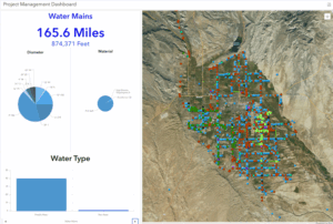
One of the most powerful features of Cloud SMART GIS® is its interactive dashboards. These dashboards combine live data from multiple sources and present it through simple visual displays that make sense at a glance. Field data, maintenance records, and real-time metrics are all brought together to help decision makers identify patterns, monitor progress, and act quickly.
Dashboards can be customized for any client or purpose. They are used to track waterline maintenance, monitor natural gas assets, manage cemetery plots, and even oversee city construction projects. Whether a team is responding to an outage or planning next year’s capital improvements, Cloud SMART GIS® provides clarity and confidence with every decision.
Empowering Clients Through Customization
What sets Cloud SMART GIS® apart is its flexibility. Instead of using rigid templates, Sunrise builds each platform around the client’s goals and workflows. The GIS team works side by side with clients to design solutions that are practical, intuitive, and easy to use. Most users can navigate, edit, and run reports without needing advanced training.
The platform is also scalable and cost-effective, making it ideal for both small towns and large utilities. Clients can begin with a simple setup and expand their system as their needs evolve. Behind every implementation is Sunrise’s experienced GIS staff, who provide setup, training, and ongoing support to help each client make the most of their system.
Real-World Results
Across the West, clients are already seeing the impact of Cloud SMART GIS®.
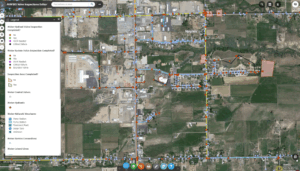
- Toquerville City modernized its utility systems by replacing paper maps with a fully digital platform that tracks water, sewer, and zoning data in one place. Field staff now update information directly from tablets, improving response times and preserving institutional knowledge.
- Virgin Valley Water District integrated thousands of pages of as-built drawings into its GIS, linking documents directly to mapped infrastructure. Staff can instantly access historical records, plan improvements, and manage compliance tasks more efficiently.
- Ashley Valley Water and Sewer Improvement District uses Cloud SMART GIS® to perform valve inspections, track maintenance, and support field operations in real time, improving collaboration between office and field staff.
Each success story shows the same result: faster decisions, better data, and stronger coordination.
The Future of Cloud SMART GIS®
Sunrise continues to enhance Cloud SMART GIS® through new technologies that are changing how clients interact with data. Artificial intelligence is being explored to automate data collection and predict infrastructure needs. IoT integration allows live monitoring of assets such as water meters and pipelines. Digital twin environments create interactive 3D models that simulate real-world conditions, helping clients plan smarter and respond faster.
As the system evolves, one thing remains constant: the human touch behind it. Every Cloud SMART GIS® implementation is backed by Sunrise’s experienced GIS professionals who are committed to creating solutions that work and relationships that last.