Experience • GIS
6 Projects Completed
GIS • Lead and Copper Solutions
On December 22, 2020, the Environmental Protection Agency (EPA) finalized the first major update to the Lead and Copper Rule since it was initially enacted in 1991. The Lead and Copper Rule is a National Primary Drinking Water Regulation under the Safe Drinking Water Act. Its purpose is to reduce lead and copper at the tap in drinking water provided by regulated public water systems.
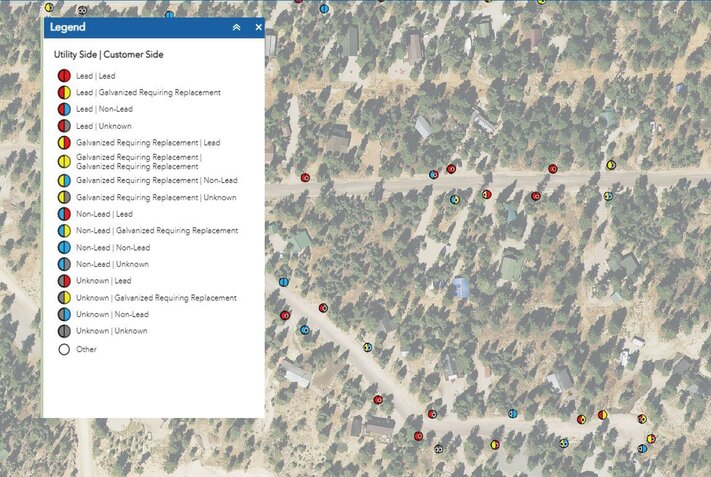
The Lead and Copper Rule Revision requires water systems to identify and make public the locations of lead service lines for both public and privately owned service lines. This inventory needs to be available to the public and can be used as a starting point for the Lead Service Line Replacement. All service lines must be classified as:
- Lead
- Galvanized steel in need of replacement (if it was ever downstream of a lead line)
- Non-lead
- Unknown*
All community and non-transient non-community public water systems are required to have and maintain an approved Lead and Copper Sample Site Plan. Various states may have varying requirements.
Lead can enter drinking water when pipes and plumbing fixtures that contain lead corrode, especially where the water has high acidity or low mineral content. Service lines with lead pipes that connect the home to the water main are the pipes that typically have the most significant source of lead in the water. Lead can affect almost every organ and system in your body. Exposure to lead may cause anemia, weakness, nervous system damage, and kidney and brain damage. Very high lead exposure can cause death. Young children and infants are particularly vulnerable to lead.
Completing an inventory by identifying lead and copper pipe in a water system will be key in replacing the lead service lines. As an ESRI® Partner and using ESRI® software, Sunrise has created solutions to provide enhanced insight into your water system. Sunrise can incorporate the city’s managed ArcGIS online systems to include lead and copper inventory of service lines. Easy-to-use tools for editing and viewing, giving the user the ability to share this information with operations staff, city councils, board members, and decision makers. The data will offer:
- Focused inventory of maintenance and repair recommendations
- A comprehensive long-term work and budget plan
- Water system visualization
- Administration of service line information
- Lead service replacement coordination
- Management dashboards
- Public information and community involvement tools
- Mobile access to manage water assets
- Detailed mapping and resource identification
- Establish high risk areas
- Prioritize replacement efforts
-
White City Water Improvement District Lead and Copper Inventory
View Project -
Orderville Town Lead and Copper Inventory
View Project -
Mt. Pleasant Lead and Copper Inventory
View Project -
LaVerkin City Lead and Copper Inventory
View Project -
Delta City Lead and Copper Inventory
View Project -
Ashley Valley Water Sewer Improvement District Lead and Copper Inventory
View Project